The spy with the gold ducats, and the duke.
Alberto Cantino walked swiftly through the dark streets of Lisbon, both elated and very nervous. Over a year of bribes and surreptitious questioning in Lisbon had finally paid off, and with what he finally had in his hands, he could expect a fine bonus from his boss.
Supposedly in Lisbon to buy horses, he was actually a spy sent by his master, an Italian duke, to procure a map. Not just any map, but the most advanced map in the whole world. Because the best maps in the world in 1502 were to be found in Portugal.
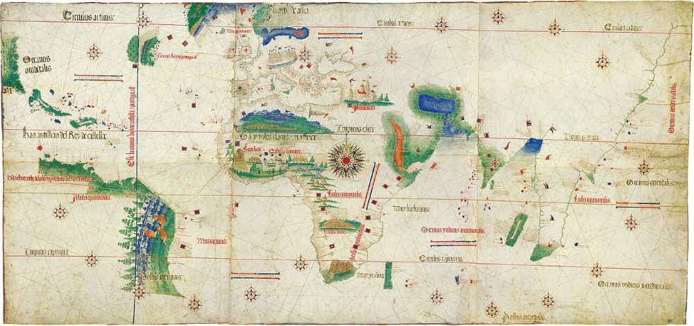
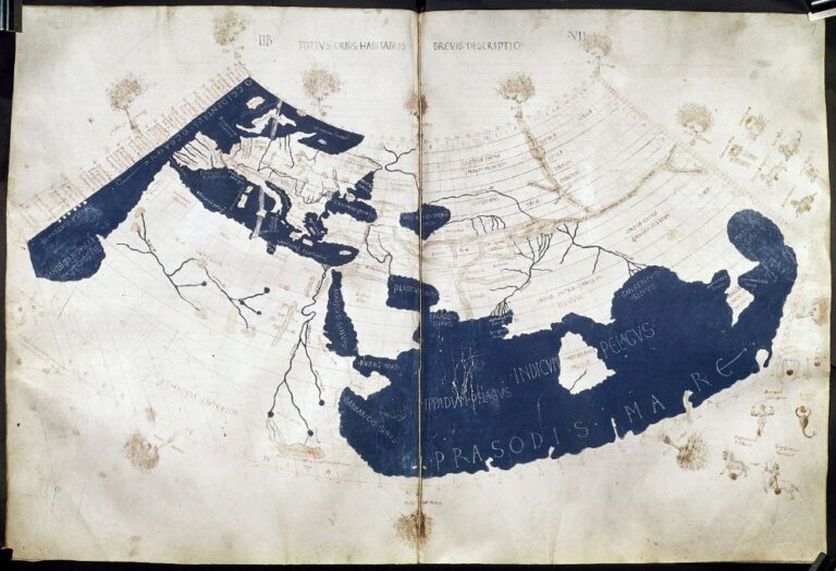
He had just secured that map–three large pages of parchment, adding up to a sheet about one by two metres–from his contact, who had been working on it for months, and that accounted for his elation. Now it was time to exit Portugal without getting caught, and that explained his anxiety. If he was apprehended by the Portuguese authorities with the map, he would be imprisoned and tortured.
And for the mapmaker he had just paid 12 ducats to, it would be much worse. Selling state secrets–maps–was a capital offence in Portugal at the start of the sixteenth century.
Portugal’s secret maps were collated following a debriefing for each returning terrestrial or maritime discovery voyage into the Padrao Real, or Royal Register, in the Warehouses of Guinea and India. It was an official from this ‘map room’ that pocketed the gold ducats in return for a hand-drawn copy of the latest update.
Cantino was lucky, soon got his map back to Italy, and presented what became known as his planisphere to the Duke of Ferrara, who was no doubt impressed. The duke ran a prosperous statelet in the powerhouse of northern Italy, but needed to continually demonstrate considerable military and diplomatic skills to keep the much larger Papal States, and the superpowers Venice and Genoa at bay.
When the duke examined the map, he was astonished. As was every other Italian who viewed it subsequently. North and South America, the Caribbean, Greenland, Newfoundland, all of Africa, India and the Far East had never been portrayed like this before. Ever.
Italy, birthplace of the Renaissance and home of the Papacy, considered itself the repository of modern geographical knowledge in all Europe. Now a backward little peasant kingdom on the remote edge of the continent had shaken the whole world order like an earthquake. The Portuguese had found a passage into the Indian Ocean, and across the seas to India!
All the priceless spices of the East, all the silks and porcelain, all the treasures that could not be found in Europe came across that ocean by ship, and then across the Levant by caravan and was then loaded on Venetian or Genoese ships for Italy. From there, the merchants of northern Europe had to pay huge markups, because they had no other choice. It was the primary business model of the north Italian city-states and had enriched them for centuries. And this map seemed to indicate that the business model’s use-by date was fast approaching.
Little Portugal kicks off the Age of Discovery
Portugal’s mid-way location between the Mediterranean and northern Europe gave it an advantage when maritime trading revived along this route during the thirteenth and fourteenth centuries. Her outlook across the wild Atlantic produced hardy, practical and adventurous sailors.
A new dynasty of kings, the House of Avis, ruled Portugal from 1383 starting with John I. During his reign, Portuguese sailors began reaching out to the west and south, along the African coast. The Azores and the Canaries were discovered (or re-discovered), and Portugal, having freed itself from Moorish rule in the thirteenth century–long before the neighbouring Spanish–began her own expansion by taking Ceuta in modern Morocco, in 1415.
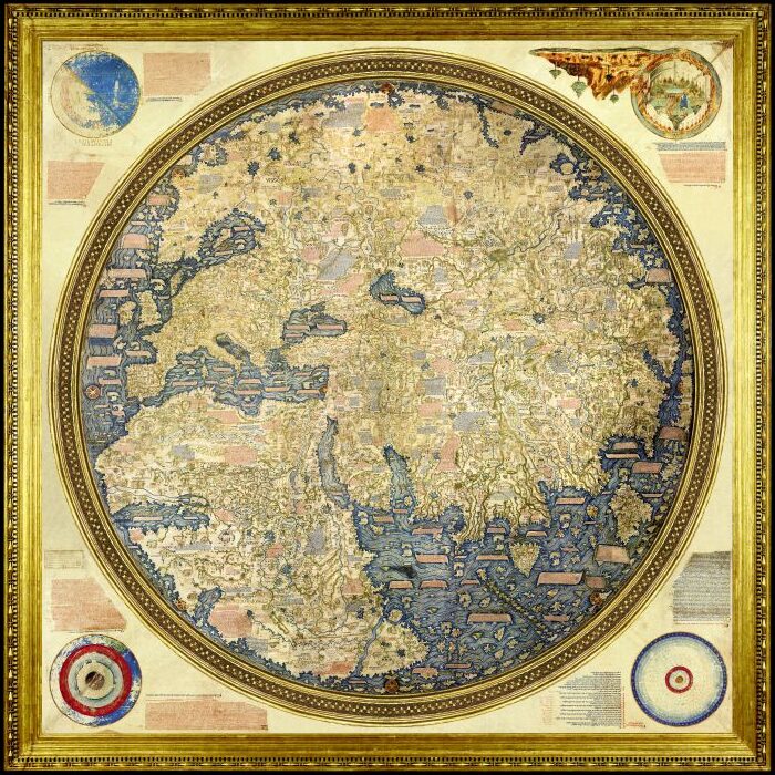
A later successor, John II, continued the theme of maritime expansion. Ocean-going ship design, celestial navigation and mapping techniques were in focus. He is said to have been fascinated by Fra Mauro’s world map of 1459; because it showed a potential sea route around the south of Africa. This would give access to the Indian Ocean, India itself, and ultimately, Marco Polo’s glittering China.
At the time, there was still considerable support in Europe for the concept of Ptolemy’s landlocked Indian Ocean. Ptolemy, living in Alexandria in the second century, had produced Geography, a treatise on how the Romans saw the world, and this text was rediscovered about the time the Avis kings were reaching out from their shores. Ptolemy envisaged a closed Indian Ocean, with no access around Africa. And, of course, the Americas were then unknown.
But the Portuguese were more inclined to view this concept as incorrect, based on the Fra Mauro map, and other maps by Macrobius, Cosmas Indicopleutes, as well as the knowledge of the Arabs, who were aware at the time the Indian Ocean was not landlocked.
With frustrating slowness, the mariners of Portugal groped gradually down the African coast, with Bartholemew Diaz finally being the first to round the Cape of Good Hope in 1488. Four years later, Columbus, who was Portuguese-trained, made it to the Caribbean, asserting he had found the ‘Indies.’ But, of course, what he had found were the unknown Americas. The Indies were still a very long way away.
Around the same time, the Portuguese also found the Americas: Brazil. This was reached by taking a ride on the trade-winds from the doorstep of Portugal southwest across the Atlantic, which avoided the contrary winds off west Africa, and provided a much faster run to the Cape of Good Hope.
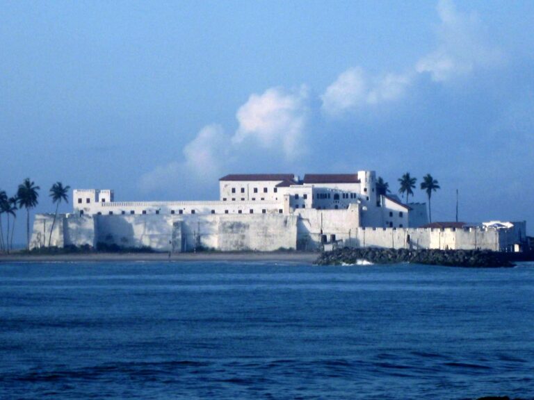
These were heady days for the Portuguese. As the century ticked over to the sixteenth, she was developing settlements in Brazil, had established a maritime route to India, and was already wealthy from the trade of gold and slaves of West Africa, where she had established a base at Elmina, in modern Ghana.
Spain and Portugal divide the world between them
Spain’s rulers, having completed the Reconquest of their country in 1492, were encouraged by Columbus’ discoveries and began their own Americas expansion. First were settlements on Hispaniola, then Cuba, followed by the mainland of South America, and then Mexico and Florida. Slaves and sugar provided the initial income, but soon silver began to flow in enormous quantities, funding the whole empire.
Early on, it became clear to both Iberian kingdoms that they would need to define the frontier between Portuguese Brazil and the Spanish settlements in the Americas. Portugal, having found a route into the Indian Ocean, was also extremely concerned that Spain would follow and impinge on its Asian targets. So, they decided to divide the undiscovered world between them!
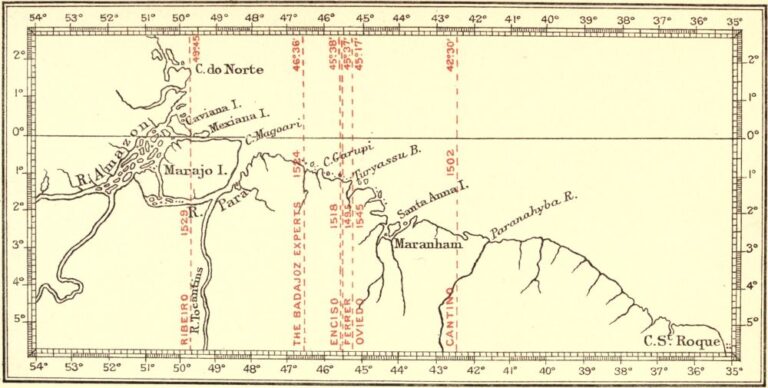
Negotiations followed for some years, culminating in the Treaty of Tordesillas being signed by the two monarchs; John of Portugal and Ferdinand of Spain, in 1493. The location of the dividing meridian between the two empires became very, very important. But it was unfortunately not clearly defined.
It was supposedly a distance of ‘370 leagues’ west of the Cape Verde Islands. The length of a league differed between the two countries, and was not clearly specified. Which of the Cape Verde Islands was not also nominated, and they extend for 300 km from east to west. It was, in any case, very difficult to accurately measure the longitude of a ship before accurate marine chronometers were available centuries later. It was all deliberately vague, and was supposed to be verified by a combined voyage–which never occurred. Both countries proffered scientific opinions about the location of the meridian, which naturally differed greatly when translated to territory on the ground in South America.
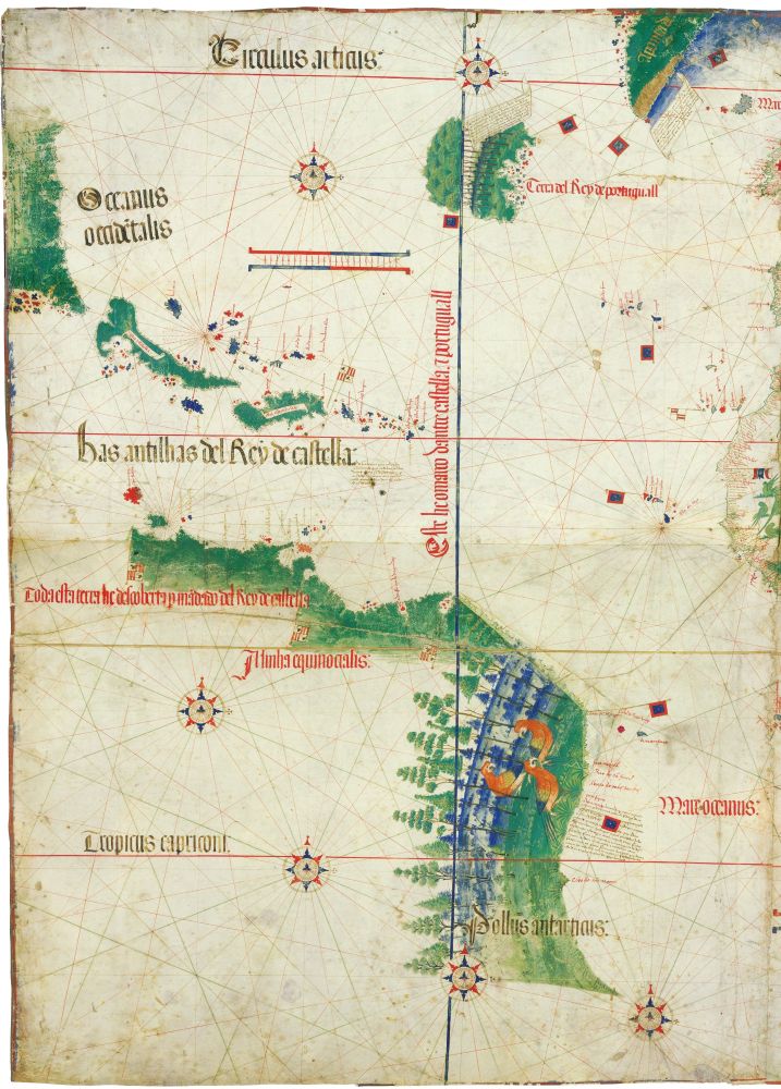
The Cantino Planisphere reflected Portugal’s first ‘official’ opinion on the location of this line.
Portuguese Cartography and Navigation
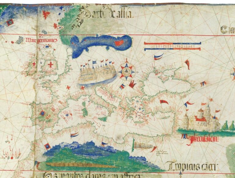
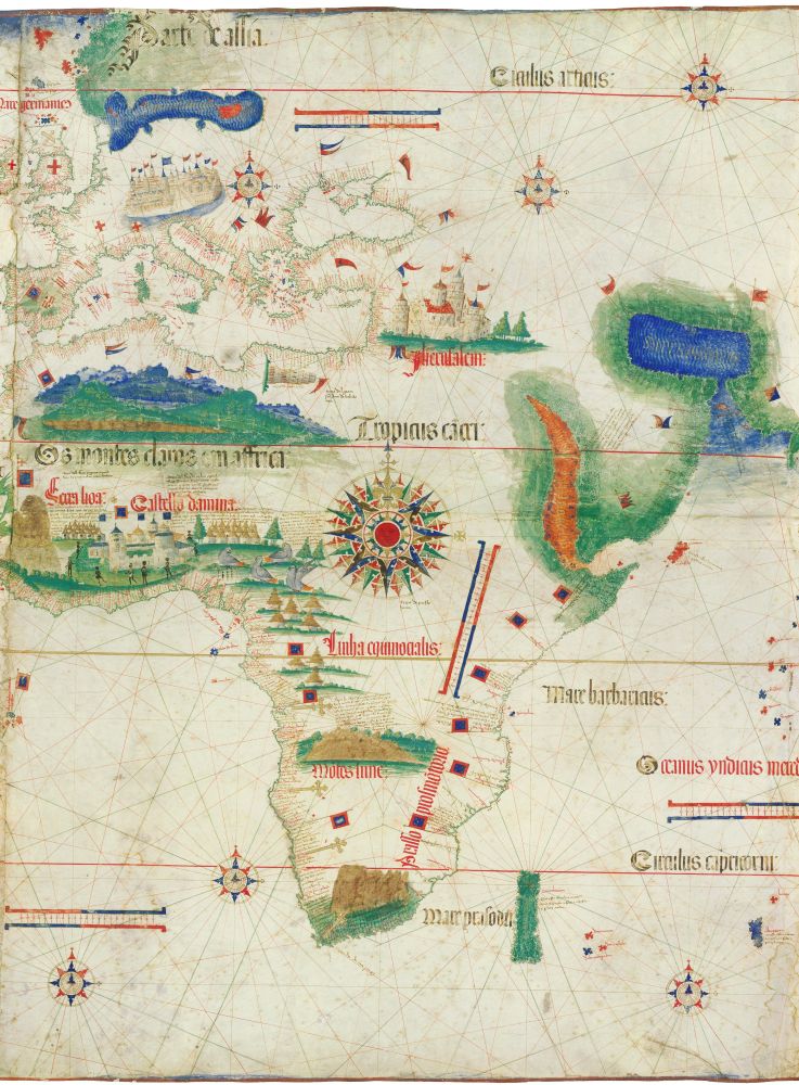
When we look at the Cantino Planisphere, we see a combination of a stunning work of art, an amazing exhibit of cartographic science, and, as we have seen, a political statement.
The artwork itself is extremely appealing, and representative of contemporary standards of Portuguese mapmaking. The colourful coastlines, mountain ranges (including Table Mountain and the Atlas Mountains), forests, depictions of inhabitants and birdlife, multi-coloured island groups and the great cities of Jerusalem and Venice all add to the artistic allure.
Beyond the appearance though are some groundbreaking mapping concepts. Whereas maritime maps of Europe were common at this time, portraying the entire known world added new challenges. The Catalan-Majorcan portolan school used rhumb lines, compass roses and named towns, harbours and other landmarks perpendicular to the coast, and these elements are prevalent across Cantino’s map.
What is new cartographically is the addition of elements of celestial navigation. While Europe is shown basically as a portolan chart, the use of the tropics and the equator to link wider regions of similar latitude on a world chart is revolutionary. It shows the Portuguese had mastered celestial navigation at sea by this time.
Also notable are several scale bars to assist with long distance navigation, including an oblique one to somewhat address the issue of there being no projection used to display the earth, an oblate spheroid, on a flat piece of parchment.
And of course, there are other mariners tools aplenty. As mentioned, the rhumb lines and compass roses were needed to plot courses. Natural features are emphasised as landmarks for piloting. Seas are coloured to flag potential shallows and littoral dangers. Island groups are shown extensively, though clearly not with great accuracy; but as a warning to navigators that hazards are in the vicinity. And the lay of the coastlines all the way from Portugal to Sumatra are shown with reasonable accuracy to assist a coasting sailor.
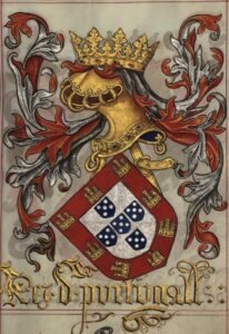
As to political statements, the Portuguese royal crest–a blue shield incorporating five more shields, all on a red flag can be seen planted from Morocco to India, and in Brazil, shouting ‘these lands are ours.’ Crosses on the south African coast represent padroes; stone pillars marking Portuguese discoveries. Elmina Castle–site of Portugal’s gold and slave base in west Africa is shown prominently, again, to warn off interlopers.
By far the most spectacular political declaration though is the Tordesillas Meridian; a north-south blue line cutting through Newfoundland all the way down to Brazil at about 42 degrees west. ‘Do not mess with our domains’, it roars to Spain.
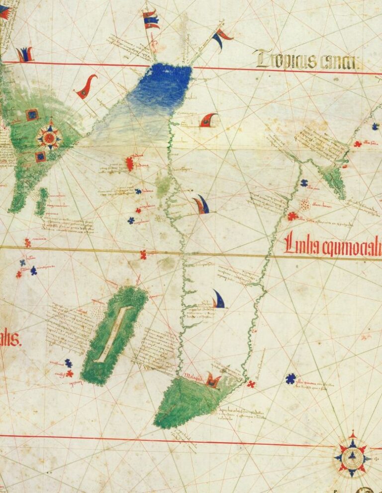
Where was the Anti-meridian?
While Brazil is shown correctly as extending south of Africa, a ‘southland’ depicted hazily south of India was perhaps meant to signify to the Spanish that there was no way around the Americas to the west. In 1502, the Portuguese had not yet made it this far south to confirm this, but they knew by then that Columbus’ Americas were not, as he maintained, the ‘Indies’ and were worried about their Iberian brethren beating them to China and the Spice Islands via a possible southern route.
This raised the issue of where the anti-meridian of the Tordesillas Meridian lay. Or, to put it another way, whose hemisphere held the priceless Spice Islands? Portuguese adventurer Ferdinand Magellan–who sailed to Malacca seven years after this map was drawn, would later sell a plan to Spain that the Spice Islands could be reached by exactly this method; sailing around South America. And of course, he estimated that they lay in the domains of Spain. He got the first point right, but the second wrong (they lay in Portugal’s sphere), and he was killed soon after, in Portuguese ‘territory.’
It was so difficult to determine the anti-meridian that after a decade of hostilities in the Indies, the Spanish relinquished their claim to the Spiceries for over a ton of gold from Portugal, in 1529.
A butchers curtain
The Cantino Planisphere remains one of the most important, if not the most important, maps of the Age of Discovery. It was the first world map to show all the main continents located according to actual exploration, and with relative accuracy. But it was very quickly obsolete. When it was drawn, Portuguese explorers had made it to India, but had only heard there of Malacca, China and Japan from others.
Not even a decade later, they conquered Malacca and by 1515 had sent an embassy to China. The only non-Iberians to follow in their footsteps that century were the French Parmentier brothers (who both died in Sumatra in 1529) and much later, Francis Drake on his circumnavigation in 1580.
Venice, under pressure in the Mediterranean from the rising Ottomans, and missing the bountiful trade revenues taken by Portugal, gradually lost ground and power, until its ultimate defeat by Napoleon. They even funded Muslim expeditions in the Indian Ocean to destroy the Portuguese. Portugal itself was swallowed by her larger neighbour in 1580, and her empire never recovered. The Duchy of Ferrara was likewise absorbed by the Papal States in 1597.
And the map? What happened to that? After taking over Ferrara, the Papal States housed Cantino’s Planisphere in a palace in Modena. During a little rioting in 1859, the palace was stormed by rebels and gutted, and for a time the map was lost.
It was very nearly another tragic permanently lost map. But in a piece of astonishing luck, the curator of the Biblioteca Estense saw the map hanging up as a curtain in a butchers shop in Modena and saved it.
It is now held in the Biblioteca in Modena, where under certain conditions, its magnificence can still be viewed.